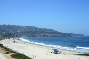
South Redondo Beach (Areas 155-157)
South Redondo Beach – Area 155
- Bounded by PCH to the west, Tom Lee Ave (just east of Prospect) to the east, Anita St to the north and Torrance Blvd. to the south.
- Comprised approx 50/50 townhomes and single family residences
- Variable lot sizes with average lot being 40×140 ft
- Schools: Beryl and Alta Vista Elementary Schools, Parras Middle School and Redondo Union High School
Home to Redondo Union High School, a multi acre campus in the heart of Redondo beachSouth Redondo Beach – Area 156
- Bounded by PCH to the west and the south, Torrance Blvd. to the north and several streets bound the eastern border which divide the cities of Redondo Beach and Torrance starting with Tom Lee Ave (just east of Prospect)
- Comprised approx 50/50 townhomes and larger single family residences
- Variable lot sizes, ask us to look this one up for you
- Schools: Alta Vista and Tulita Elementary Schools, Parras Middle School and Redondo Union High School
Encompasses Alta Vista ParkSouth Redondo – Area 157
- Bounded by the Pacific Ocean to the west (Harbor Dr., Catalina Ave, Esplanade), PCH to the east, Anita St to the north and a jagged southern boundary that separates Redondo Beach from the Hollywood Riviera (a portion of Torrance) to the south (near Palos Verdes Blvd)
- Comprised primarily of townhomes, original beach cottages and large condominium developments, as well as several ocean front apartment buildings at the south most end of the Esplanade.
- Lot sizes for single family residences are approx. 40×150 ft
- Schools: Alta Vista and Tulita Elementary Schools, Parras Middle School and Redondo Union High School
Encompasses the King Harbor and the Redondo Beach Pier, the Esplanade and Veterans Park

